
 |
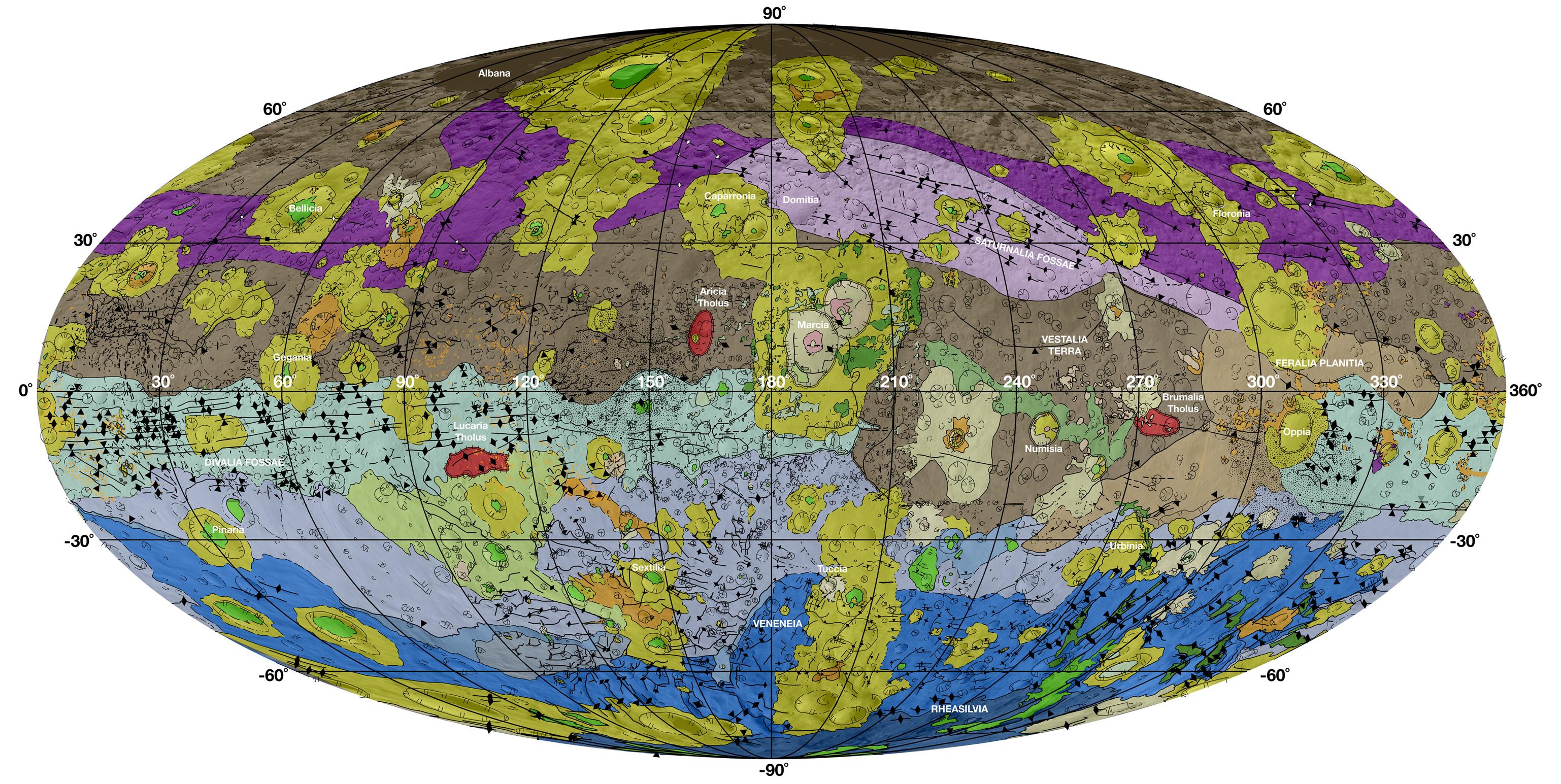
| "click on image to enlarge" This high-resolution geological map of Vesta is derived from Dawn spacecraft data. Credit: NASA/JPL-Caltech/ASU |
JPL manages the Dawn mission for NASA's Science Mission Directorate in Washington. Dawn is a project of the directorate's Discovery Program, managed by NASA's Marshall Space Flight Center in Huntsville, Alabama. The University of California at Los Angeles (UCLA) is responsible for overall Dawn mission science. Orbital Sciences Corp. in Dulles, Virginia, designed and built the spacecraft. The German Aerospace Center, the Max Planck Institute for Solar System Research, the Italian Space Agency and the Italian National Astrophysical Institute are international partners on the mission team.
Download Full-Res TIFF: PIA18788.tif (14.26 MB)
Download Full-Res JPG: PIA18788.jpg (1.03 MB)
View all Images
More information about Dawn is online at http://www.nasa.gov/dawn.
 |
| "click on image to enlarge" Vesta Topography Map Credit- NASA/JPL-Caltech/UCLA/MPS/DLR/IDA/PSI |
This color-coded topography map from NASA's Dawn mission shows the giant asteroid Vesta in an equirectangular projection at 32 pixels per degree, relative to an ellipsoid of 177 miles by 177 miles by 142 miles (285 kilometers by 285 kilometers by 229 kilometers). The color scale extends from 13.96 miles (22.47 kilometers) below the surface in purple to 12.11 miles (19.48 kilometers) above the surface in white. The topographic map was constructed from analyzing more than 17,000 images from Dawn's framing camera that were taken with varying sun and viewing angles.
The Dawn mission to Vesta and Ceres is managed by NASA's Jet Propulsion Laboratory, a division of the California Institute of Technology in Pasadena, for NASA's Science Mission Directorate, Washington. The University of California, Los Angeles, is responsible for overall Dawn mission science. The Dawn framing cameras were developed and built under the leadership of the Max Planck Institute for Solar System Research, Katlenburg-Lindau, Germany, with significant contributions by DLR German Aerospace Center, Institute of Planetary Research, Berlin, and in coordination with the Institute of Computer and Communication Network Engineering, Braunschweig. The framing camera project is funded by the Max Planck Society, DLR and NASA.
More information on Dawn is available at: http://www.nasa.gov/dawn and http://dawn.jpl.nasa.gov .
------
NOVEMBER 17, 2014
Geologic Maps of Vesta from NASA's Dawn Mission Published
Images from NASA's Dawn Mission have been used to create a series of high-resolution geological maps of the large asteroid Vesta, revealing the variety of surface features in unprecedented detail. These maps are included with a series of 11 scientific papers published this week in a special issue of the journal Icarus.
Geological mapping is a technique used to derive the geologic history of a planetary object from detailed analysis of surface morphology, topography, color and brightness information. A team of 14 scientists mapped the surface of Vesta using Dawn spacecraft data, led by three NASA-funded participating scientists: David A. Williams of Arizona State University, Tempe; R. Aileen Yingst of the Planetary Science Institute, Tucson, Arizona; and W. Brent Garry of the NASA Goddard Spaceflight Center, Greenbelt, Maryland.
"The geologic mapping campaign at Vesta took about two-and-a-half years to complete, and the resulting maps enabled us to recognize a geologic timescale of Vesta for comparison to other planets," said Williams.
Scientists discovered through these maps that impacts from several large meteorites have shaped Vesta's history. Asteroids like Vesta are remnants of the formation of the solar system, giving scientists a peek at its history. Asteroids could also harbor molecules that are the building blocks of life and reveal clues about the origins of life on Earth.
The geologic mapping of Vesta is enabled by images obtained by the framing camera provided by the Max Planck Institute for Solar System Research of the German Max Planck Society and the German Aerospace Center. This camera takes panchromatic images and seven bands of color-filtered images. Stereo photos are used to create topographic models of the surface that aid in the geologic interpretation.
Vesta's geologic timescale is determined by the sequence of large impact events, primarily by the Veneneia and Rheasilvia impacts in Vesta's early history and the Marcia impact in its late history. The oldest crust on Vesta pre-dates the Veneneia impact.The relative timescale is supplemented by model-based absolute ages from two different approaches that apply crater statistics to date the surface.
"This mapping was crucial for getting a better understanding of Vesta's geological history, as well as providing context for the compositional information that we received from other instruments on the spacecraft: the visible and infrared (VIR) mapping spectrometer and the gamma-ray and neutron detector (GRaND)," said Carol Raymond, Dawn's deputy principal investigator at NASA's Jet Propulsion Laboratory in Pasadena, California.
The objective of NASA's Dawn mission is to characterize the two most massive objects in the main asteroid belt between Mars and Jupiter - Vesta and the dwarf planet Ceres. The spacecraft launched in 2007. Vesta, orbited by the Dawn spacecraft between July 2011 and September 2012, was thought to be the source of a unique set of basaltic meteorites (called HEDs, for howardite-eucrite-diogenite), and Dawn confirmed the Vesta-HED connection.
The Dawn spacecraft is currently on its way to Ceres, the largest object in the asteroid belt. Dawn will arrive at Ceres in March 2015.
Dawn uses ion propulsion in spiraling trajectories to travel from Earth to Vesta, orbit Vesta and then continue on to orbit the dwarf planet Ceres. Ion engines use very small amounts of onboard fuel, enabling a mission that would be unaffordable or impossible without them.
JPL manages the Dawn mission for NASA's Science Mission Directorate in Washington. Dawn is a project of the directorate's Discovery Program, managed by NASA's Marshall Space Flight Center in Huntsville, Alabama. The University of California at Los Angeles (UCLA) is responsible for overall Dawn mission science. Orbital Sciences Corp. in Dulles, Virginia, designed and built the spacecraft. The German Aerospace Center, the Max Planck Institute for Solar System Research, the Italian Space Agency and the Italian National Astrophysical Institute are international partners on the mission team.
For more information about Dawn, visit:
http://www.nasa.gov/dawn
Media Contact
Elizabeth Landau
NASA's Jet Propulsion Laboratory, Pasadena, Calif.
818-354-6425
Elizabeth.Landau@jpl.nasa.gov
Robert Burnham
Arizona State University, Tempe, Ariz.
480-458-8207
Robert.Burnham@asu.edu
Press Release 2014-399
2014 The Year of "CERTAIN Uncertainty" ™; Meteors, Asteroids, Comets, and MORE!!
NASA's Jet Propulsion Laboratory, Pasadena, Calif.
818-354-6425
Elizabeth.Landau@jpl.nasa.gov
Robert Burnham
Arizona State University, Tempe, Ariz.
480-458-8207
Robert.Burnham@asu.edu
Press Release 2014-399
2014 The Year of "CERTAIN Uncertainty" ™; Meteors, Asteroids, Comets, and MORE!!
No comments:
Post a Comment